Training Course on Geospatial Data Pipelines for Web Applications
Training Course on Geospatial Data Pipelines for Web Applications will equip participants with the essential skills and knowledge to design, build, and deploy efficient geospatial data pipelines.
Skills Covered
Course Overview
Training Course on Geospatial Data Pipelines for Web Applications
Introduction
In today's rapidly evolving digital landscape, the ability to effectively manage, process, and visualize geospatial data is paramount for a myriad of industries, from urban planning and environmental monitoring to logistics and smart cities. Traditional approaches to handling spatial information often struggle with the sheer volume and velocity of modern data streams. This necessitates the adoption of robust and scalable solutions: Geospatial Data Pipelines. These automated workflows are designed to ingest, transform, analyze, and deliver location-based insights to web applications, enabling real-time decision-making and dynamic visualization.
Training Course on Geospatial Data Pipelines for Web Applications will equip participants with the essential skills and knowledge to design, build, and deploy efficient geospatial data pipelines. Focusing on cutting-edge open-source technologies, cloud computing, and AI-driven geospatial analysis, learners will master the entire lifecycle of spatial data, from raw input to interactive web maps and dashboards. Through practical, hands-on exercises and real-world case studies, attendees will gain proficiency in data acquisition, processing, storage (e.g., PostGIS, GeoJSON), analysis, and serving via web services, ultimately empowering them to create sophisticated and highly responsive geospatial web applications.
Course Duration
10 days
Course Objectives
Upon completion of this training course, participants will be able to:
- Design and Architect robust Geospatial Data Pipelines for web applications.
- Master Data Ingestion from diverse geospatial data sources (e.g., APIs, sensors, satellite imagery).
- Perform Data Cleaning and Transformation for spatial datasets, ensuring data quality and consistency.
- Utilize PostGIS for efficient spatial database management and complex spatial queries.
- Implement real-time geospatial processing techniques for dynamic web applications.
- Leverage cloud-based GIS solutions (e.g., AWS, Azure, Google Cloud Platform) for scalable infrastructure.
- Develop Geospatial Web Services (WMS, WFS, WMTS) using open-source tools like GeoServer.
- Build interactive and responsive web mapping applications using JavaScript libraries (e.g., Leaflet.js, OpenLayers).
- Integrate AI-driven geospatial analysis and machine learning into data pipelines.
- Apply Location Intelligence principles to extract actionable insights from spatial data.
- Understand and implement Geospatial Big Data processing techniques.
- Ensure data security and privacy within geospatial data pipelines.
- Troubleshoot and optimize geospatial data workflows for performance and efficiency.
Organizational Benefits
- Empowering teams with real-time, location-based insights leads to more informed and agile decisions across various departments, from operations to strategic planning.
- Automation of data processing and analysis through pipelines reduces manual effort, minimizes errors, and accelerates the delivery of critical spatial information.
- Organizations can handle increasing volumes of geospatial data and user demand by leveraging scalable cloud infrastructure and optimized pipeline designs.
- The ability to develop and deploy advanced geospatial web applications fosters innovation, enabling new services, products, and a competitive edge in data-driven markets.
- Optimizing data workflows, reducing redundant data processing, and leveraging open-source technologies can lead to substantial cost savings in data management and infrastructure.
- By visualizing and analyzing spatial patterns, organizations can optimize resource allocation, manage assets effectively, and streamline field operations.
- Making complex geospatial data accessible and understandable through intuitive web applications democratizes information, allowing non-GIS specialists to utilize spatial insights.
- Proactive identification of spatial risks and trends through real-time analysis improves preparedness and response capabilities for various challenges, including environmental or logistical disruptions.
Target Audience
- GIS Professionals & Analysts.
- Web Developers
- Data Scientists & Engineers.
- Urban Planners & Smart City Developers
- Environmental Scientists & Researchers.
- Logistics & Supply Chain Managers
- Remote Sensing Specialists
- IT Professionals & System Architects
Course Outline
Module 1: Introduction to Geospatial Data Pipelines & Web GIS
- Understanding the Geospatial Data Ecosystem
- Evolution of Web GIS
- Introduction to Data Pipelines
- Key Principles of Geospatial Data Pipelines
- Overview of Open-Source Geospatial Technologies
- Case Study: Analyzing the evolution of a city's public transport network through historical GIS data presented on an interactive web map.
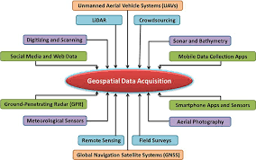
Module 2: Geospatial Data Acquisition & Ingestion
- Methods of Data Collection
- Working with Geospatial APIs
- Batch vs. Streaming Data Ingestion
- Data Connectors and ETL Tools
- Data Formats for Web Applications
- Case Study: Ingesting real-time traffic data from an external API to visualize congestion patterns on a live map.
Module 3: Spatial Databases with PostGIS
- Introduction to PostGIS.
- Spatial Data Types and Functions.
- Indexing and Performance Optimization
- Spatial Relationships and Operations.
- Connecting Applications to PostGIS
- Case Study: Building a land parcel management system where property boundaries and attributes are stored and queried efficiently in PostGIS.
Module 4: Geospatial Data Cleaning & Transformation
- Data Quality Issues in Geospatial Data
- Geospatial Data Validation Techniques:
- Coordinate Reference System (CRS) Management
- Data Aggregation and Simplification
- Handling Large Datasets
- Case Study: Cleaning and reprojecting historical cadastral data from various sources into a unified, web-ready format.
Module 5: Geospatial Data Storage & Management Strategies
- Centralized vs. Distributed Storage
- Cloud Storage Solutions for Geospatial Data
- Geospatial Data Versioning and Archiving:
- Metadata Management for Geospatial Data
- Data Security and Access Control
- Case Study: Designing a scalable cloud-based storage solution for a national satellite imagery archive, ensuring easy access and version control.
Module 6: Building Geospatial Web Services with GeoServer
- Introduction to GeoServer
- Publishing Vector and Raster Data
- Styling Data with SLD (Styled Layer Descriptor)
- Security and Performance Tuning in GeoServer
- Integrating GeoServer with Web Applications.
- Case Study: Publishing real-time environmental sensor data via GeoServer WMS, accessible for public consumption on a web dashboard.
Module 7: Frontend Web Mapping with Leaflet.js and OpenLayers
- Fundamentals of Web Mapping Libraries
- Displaying Basemaps and Overlay Layers.
- Interactivity and User Experience (UX).
- Data Visualization on the Web.
- Client-Side Spatial Operations
- Case Study: Developing an interactive web map for disaster response, allowing users to visualize affected areas, shelters, and aid distribution points.
Module 8: Advanced Geospatial Data Visualization
- Thematic Mapping Techniques.
- Time-Series Geospatial Data Visualization.
- 3D Geospatial Visualization.
- Leveraging WebGL for High-Performance Mapping:
- Building Custom Map Components
- Case Study: Visualizing urban growth over several decades using animated time-series maps, highlighting population density changes.
Module 9: Cloud-Native Geospatial Architectures
- Serverless Geospatial Computing.
- Containerization with Docker.
- Orchestration with Kubernetes
- Cloud-based Databases for Geospatial.
- CI/CD for Geospatial Applications.
- Case Study: Deploying a serverless application that processes newly uploaded drone imagery and publishes results to a web map automatically.
Module 10: Integrating AI & Machine Learning in Geospatial Pipelines
- Introduction to AI/ML for Geospatial
- Geospatial Feature Engineering
- Supervised and Unsupervised Learning on Spatial Data
- Deep Learning for Remote Sensing
- MLOps for Geospatial
- Case Study: Using machine learning to detect changes in land cover from satellite imagery, automatically updating a web application with deforestation alerts.
Module 11: Real-time Geospatial Data Processing
- Stream Processing Concepts.
- Message Queues for Geospatial Streams.
- Real-time Spatial Analytics.
- WebSockets for Live Map Updates:.
- Edge Computing for Geospatial Sensors.
- Case Study: Developing a real-time tracking system for a fleet of delivery vehicles, displaying their live positions and estimated arrival times on a web map.
Module 12: Geospatial Big Data & Distributed Processing
- Challenges of Big Geospatial Data
- Distributed Computing Frameworks
- Geospatial Libraries for Big Data.
- Parallel Processing for Raster and Vector Data
- Data Lake vs. Data Warehouse for Geospatial
- Case Study: Processing petabytes of weather radar data to generate real-time precipitation forecasts for a regional web application.
Module 13: Geospatial Data Security & Governance
- Threats to Geospatial Data.
- Access Control and Authentication.
- Data Encryption in Transit and At Rest
- Privacy Concerns with Location Data.
- Data Governance Frameworks for Geospatial
- Case Study: Securing a public-facing web application that displays sensitive infrastructure data, ensuring only authorized personnel can access detailed information.
Module 14: Performance Optimization & Monitoring
- Database Performance Tuning.
- Web Service Optimization.
- Frontend Performance Best Practices.
- Monitoring and Alerting.
- Troubleshooting Common Geospatial Pipeline Issues.
- Case Study: Optimizing a national mapping portal to handle millions of simultaneous users by implementing caching strategies and load balancing for its geospatial services.
Module 15: Deployment & Maintenance of Geospatial Web Applications
- Deployment Strategies
- Automated Deployment with DevOps Tools
- Maintenance and Updates