Gis integration Courses
Explore instructor-led and hybrid programs aligned to practical Gis integration use cases across industries.
Available Gis integration Courses
Showing 1-8 of 8 courses

5 days
Accra, Addis Ababa, Bangkok, Cape Town, Dubai, Istanbul, Kigali, Nairobi, Singapore
GIS Data Integration Training Course
GIS Data Integration Training Course equips professionals with the technical expertise to merge spatial and non-spatial datasets, implement automated workflows, and apply geospatial intelligence for diverse applications such as urban planning, environmental monitoring, and infrastructure development.
GIS Data Integration Training Course equips professionals with the technical expertise to merge spatial and non-spatial datasets, implement automated workflows, and apply geospatial intelligence for diverse applications such as urban planning, environmental monitoring, and infrastructure development.

5 days
Accra, Addis Ababa, Bangkok, Cape Town, Dubai, Istanbul, Kigali, Nairobi, Singapore
Spatial Econometrics in Models and Applications Training Course
Spatial Econometrics in Models and Applications Design Training Course focuses on cutting-edge models, statistical applications, and spatial regression techniques to equip participants with hands-on skills to address complex spatial challenges in real-world contexts.
Spatial Econometrics in Models and Applications Design Training Course focuses on cutting-edge models, statistical applications, and spatial regression techniques to equip participants with hands-on skills to address complex spatial challenges in real-world contexts.

10 days
Accra, Addis Ababa, Bangkok, Cape Town, Dubai, Istanbul, Kigali, Nairobi, Singapore
Training Course on Building Custom AI Models for GIS Workflows
Training Course on Building Custom AI Models for GIS Workflows is meticulously designed to equip GIS professionals, data scientists, and spatial analysts with the cutting-edge skills required to develop and integrate custom Artificial Intelligence (AI) models directly into their Geospatial Information Systems (GIS) workflows.
Training Course on Building Custom AI Models for GIS Workflows is meticulously designed to equip GIS professionals, data scientists, and spatial analysts with the cutting-edge skills required to develop and integrate custom Artificial Intelligence (AI) models directly into their Geospatial Information Systems (GIS) workflows.
10 days
Accra, Addis Ababa, Bangkok, Cape Town, Dubai, Istanbul, Kigali, Nairobi, Singapore
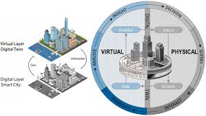
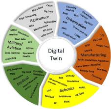
Training Course on Digital Twin for Urban Operations and Planning
Training Course on Digital Twin for Urban Operations and Planning is designed to equip professionals with the essential knowledge and practical skills to leverage this transformative technology.
Training Course on Digital Twin for Urban Operations and Planning is designed to equip professionals with the essential knowledge and practical skills to leverage this transformative technology.
10 days
Accra, Addis Ababa, Bangkok, Cape Town, Dubai, Istanbul, Kigali, Nairobi, Singapore
Training Course on Digital Twin Technology and Geospatial Integration
Training Course on Digital Twin Technology and Geospatial Integration delves into the convergence of real-time digital replicas with the power of geospatial intelligence, offering unprecedented insights into complex physical assets and systems.
Training Course on Digital Twin Technology and Geospatial Integration delves into the convergence of real-time digital replicas with the power of geospatial intelligence, offering unprecedented insights into complex physical assets and systems.

10 days
Accra, Addis Ababa, Bangkok, Cape Town, Dubai, Istanbul, Kigali, Nairobi, Singapore
Training Course on Image Segmentation and Feature Extraction Techniques
Training Course on Image Segmentation and Feature Extraction Techniques is designed to equip professionals with cutting-edge skills in computer vision and image processing, leveraging both traditional and deep learning approaches.
Training Course on Image Segmentation and Feature Extraction Techniques is designed to equip professionals with cutting-edge skills in computer vision and image processing, leveraging both traditional and deep learning approaches.

5 days
Accra, Addis Ababa, Bangkok, Cape Town, Dubai, Istanbul, Kigali, Nairobi, Singapore
Urban Data Analytics and Smart Cities Research Training Course
Urban Data Analytics and Smart Cities Research Training Course equips professionals, researchers, and policymakers with practical skills and theoretical knowledge to harness data-driven decision-making in urban environments.
Urban Data Analytics and Smart Cities Research Training Course equips professionals, researchers, and policymakers with practical skills and theoretical knowledge to harness data-driven decision-making in urban environments.
10 days
Accra, Addis Ababa, Bangkok, Cape Town, Dubai, Istanbul, Kigali, Nairobi, Singapore
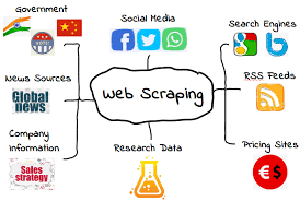
Web Scraping and Data Collection for Geospatial Projects Training Course
Web Scraping and Data Collection for Geospatial Projects Training Course is meticulously designed to empower professionals with the essential skills to automate data acquisition, transform unstructured web content into valuable spatial insights, and integrate diverse datasets for robust geospatial analysis
Web Scraping and Data Collection for Geospatial Projects Training Course is meticulously designed to empower professionals with the essential skills to automate data acquisition, transform unstructured web content into valuable spatial insights, and integrate diverse datasets for robust geospatial analysis