Training Course on Georeferencing and Mapping Accuracy with Drones
Training Course on Georeferencing and Mapping Accuracy with Drones equips participants with the essential knowledge and practical skills to confidently plan, execute, and process drone-based mapping projects, ensuring the highest levels of data quality and spatial integrity
Skills Covered
Course Overview
Training Course on Georeferencing and Mapping Accuracy with Drones
Introduction
Unlock the full potential of drone technology for precise spatial data acquisition with our comprehensive training course on Georeferencing and Mapping Accuracy. In today's rapidly evolving geospatial landscape, the ability to generate reliable and spatially accurate maps and models from drone imagery is paramount across numerous industries. Training Course on Georeferencing and Mapping Accuracy with Drones equips participants with the essential knowledge and practical skills to confidently plan, execute, and process drone-based mapping projects, ensuring the highest levels of data quality and spatial integrity. Learn industry best practices in flight planning, ground control point (GCP) deployment, photogrammetry, and advanced processing techniques to achieve exceptional mapping accuracy and contribute valuable insights to your organization.
This course delves into the critical aspects of ensuring geospatial accuracy in drone mapping workflows. We explore the nuances of coordinate reference systems, the impact of sensor calibration, and the methodologies for rigorous error assessment and quality control. Through hands-on exercises and real-world case studies, you will gain practical experience in optimizing your data acquisition and processing pipelines. By mastering the techniques taught in this course, you will be able to produce highly accurate orthomosaics, digital surface models (DSMs), and other geospatial deliverables, enhancing your organization's capabilities in spatial analysis, environmental monitoring, infrastructure management, and beyond.
Course Duration
5 days
Course Objectives
Upon completion of this training course, participants will be able to:
- Understand the fundamental principles of georeferencing in the context of drone mapping.
- Plan drone missions effectively to optimize spatial accuracy and data quality.
- Strategically deploy and accurately measure Ground Control Points (GCPs) for precise georeferencing.
- Apply various coordinate reference systems and perform coordinate transformations.
- Process drone imagery using photogrammetry software to generate georeferenced outputs.
- Assess and improve the geometric accuracy of drone-derived maps and models.
- Implement effective quality control measures throughout the drone mapping workflow.
- Troubleshoot common errors affecting mapping accuracy in drone projects.
- Utilize Real-Time Kinematic (RTK) and Post-Processed Kinematic (PPK) techniques for enhanced accuracy.
- Integrate drone-derived geospatial data with other GIS platforms and datasets.
- Apply best practices for data management and archiving of georeferenced drone data.
- Understand the regulatory landscape and safety guidelines for commercial drone operations.
- Analyze real-world case studies demonstrating successful georeferencing and mapping accuracy.
Organizational Benefits
- Improved data-driven decision-making through access to highly accurate spatial information.
- Increased efficiency in spatial data collection compared to traditional methods.
- Enhanced project accuracy and reduced errors in mapping and surveying tasks.
- Greater insights into environmental changes and infrastructure conditions through precise monitoring.
- Cost savings through optimized resource allocation and reduced rework due to inaccurate data.
- Competitive advantage by leveraging cutting-edge drone mapping technology.
- Enhanced collaboration and communication through standardized and accurate geospatial data.
- Improved compliance with regulatory requirements for spatial data reporting.
Target Audience
- Surveyors and Geomatics Engineers
- GIS Professionals and Analysts
- Environmental Scientists and Consultants
- Agriculture and Forestry Specialists
- Infrastructure and Construction Managers
- Archaeologists and Researchers
- Public Safety and Emergency Responders
- Drone Service Providers and Operators
Course utline
Module 1: Fundamentals of Georeferencing and Coordinate Systems
- Introduction to geospatial data and its importance.
- Understanding different types of coordinate reference systems (e.g., Geographic, Projected).
- Datum transformations and their impact on accuracy.
- Working with map projections and their properties.
- Case Study: Selecting the appropriate coordinate system for a large-scale infrastructure project.
Module 2: Drone Technology and Sensor Calibration for Mapping
- Overview of different types of drones used for mapping (e.g., multi-rotor, fixed-wing).
- Understanding camera sensors and their specifications.
- Importance of camera calibration for accurate photogrammetry.
- Introduction to radiometric and geometric calibration.
- Case Study: The impact of poor camera calibration on the accuracy of a 3D model.
Module 3: Mission Planning and Flight Execution for Optimal Accuracy
- Principles of effective flight planning for mapping projects.
- Determining optimal flight parameters (altitude, overlap, speed).
- Using flight planning software and applications.
- Safety considerations and regulatory compliance.
- Case Study: Planning a drone mission to map a complex agricultural landscape.
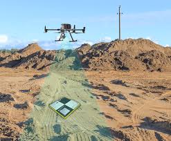
Module 4: Ground Control Points (GCPs): Theory and Practical Deployment
- The role of GCPs in achieving high georeferencing accuracy.
- Best practices for selecting and distributing GCP locations.
- Methods for accurately surveying GCPs (e.g., RTK GPS).
- Marking and identifying GCPs in drone imagery.
- Case Study: Implementing a GCP network for a high-precision topographic survey.
Module 5: Photogrammetric Processing for Accurate Orthomosaics and DSMs
- Introduction to photogrammetry principles and workflows.
- Image alignment, bundle block adjustment, and georeferencing.
- Generating accurate orthomosaics and Digital Surface Models (DSMs).
- Understanding and mitigating sources of error in processing.
- Case Study: Processing drone imagery to create a high-resolution orthomosaic of an urban area.
Module 6: Advanced Georeferencing Techniques: RTK and PPK
- Understanding the principles of Real-Time Kinematic (RTK) positioning.
- Implementing RTK workflows for direct georeferencing.
- Introduction to Post-Processed Kinematic (PPK) techniques.
- Comparing the advantages and disadvantages of RTK and PPK.
- Case Study: Using PPK for accurate mapping in areas with limited network connectivity.
Module 7: Accuracy Assessment and Quality Control in Drone Mapping
- Methods for assessing the geometric accuracy of drone-derived products.
- Using independent check points for validation.
- Implementing quality control procedures throughout the workflow.
- Generating accuracy reports and documentation.
- Case Study: Assessing the accuracy of a drone-derived elevation model for flood risk assessment.
Module 8: Integration with GIS and Applications of Accurate Drone Mapping
- Importing and integrating drone-derived data into GIS platforms.
- Applications of accurate drone mapping in various industries (e.g., environmental monitoring, infrastructure inspection).
- Analyzing and visualizing georeferenced drone data.
- Future trends and advancements in drone mapping technology.
- Case Study: Utilizing accurate drone maps for infrastructure asset management and monitoring.
Training Methodology
This course employs a blended learning approach, combining:
- Interactive lectures and presentations covering theoretical concepts.
- Hands-on practical exercises using industry-standard software.
- Real-world case studies and discussions to illustrate key principles.
- Group activities and problem-solving sessions.
- Opportunities for Q&A and direct interaction with the instructor.
Register as a group from 3 participants for a Discount
Send us an email: info@datastatresearch.org or call +254724527104
Certification
Upon successful completion of this training, participants will be issued with a globally- recognized certificate.
Tailor-Made Course
We also offer tailor-made courses based on your needs.
Key Notes
a. The participant must be conversant with English.
b. Upon completion of training the participant will be issued with an Authorized Training Certificate
c. Course duration is flexible and the contents can be modified to fit any number of days.
d. The course fee includes facilitation training materials, 2 coffee breaks, buffet lunch and A Certificate upon successful completion of Training.
e. One-year post-training support Consultation and Coaching provided after the course.
f. Payment should be done at least a week before commence of the training, to DATASTAT CONSULTANCY LTD account, as indicated in the invoice so as to enable us prepare better for you.